Not one project. A sequence of better questions.
The research programme changed each time the evidence exposed a new limitation. More sensors created spatial detail. Health data changed what that detail meant. Meteorology challenged simple interpretations. Indoor exposure made the city boundary porous. And a change in the commercial monitoring model forced a much more fundamental question about ownership and resilience.
Can we build a useful low-cost sensor?
Early Sensor City work set out to move from in-house prototypes towards robust, connected monitors capable of measuring particulate matter alongside gases and meteorology. The ambition was practical from the start: distribute them around Liverpool and make local air pollution visible at a scale conventional monitoring could not provide.
Prototype → deployable sensingCan monitoring change what happens to a child?
The Breathing City work with Alder Hey moved the question indoors and into healthcare. Residential monitoring around children with suspected pollution-related respiratory disease connected outdoor conditions, homes, clinical questions and socioeconomic deprivation. The sensor stopped being the endpoint; exposure and action became the point.
Indoor + outdoor exposureCan we separate human activity from the weather?
UK-wide COVID research used mobility, traffic and meteorology to understand why pollution changed when behaviour changed. It reinforced a lesson that would become central later: a pollution peak is not self-explanatory. Weather, movement and place must be considered before turning data into a claim.
Mobility + meteorologyCan the city map meet the hospital map?
Work presented with Alder Hey began linking particulate matter maps with paediatric asthma emergency activity. At the same time the first Roundtable put clinicians, councils, researchers, charities and industry around the same table. The evidence and the stakeholder network started growing together.
Environment + clinical dataWho is exposed — and who can actually act?
The second Roundtable made child respiratory health, deprivation, schools, vehicle cabins and indoor air central. Teacher CPD then carried the work into classrooms. The research programme was no longer confined to measuring the city; it was beginning to ask how evidence moves through health, education and public decision making.
Health + schools + responsibilityCan dense monitoring reveal unequal exposure?
A cluster of Liverpool-focused publications moved the programme into a more mature phase: extracting spatial modes from the network, analysing pollution alongside socioeconomic deprivation, and linking particulate exposure, deprivation and paediatric respiratory admissions. The emerging picture was not simply where pollution was highest, but where environmental and social risk overlapped.
Spatial intelligence + environmental justiceHow do we turn density into defensible evidence?
Current work is pushing beyond attractive maps towards evidence systems that explicitly audit sensor coverage, reference agreement, meteorology, spatial uncertainty and source proxies. In parallel, health work is expanding into deprivation, housing and fuel poverty, while particle-level analysis is asking what the particulate matter itself can tell us about sources and chemistry.
Quality assurance + translationDense monitoring changed what Liverpool could ask.
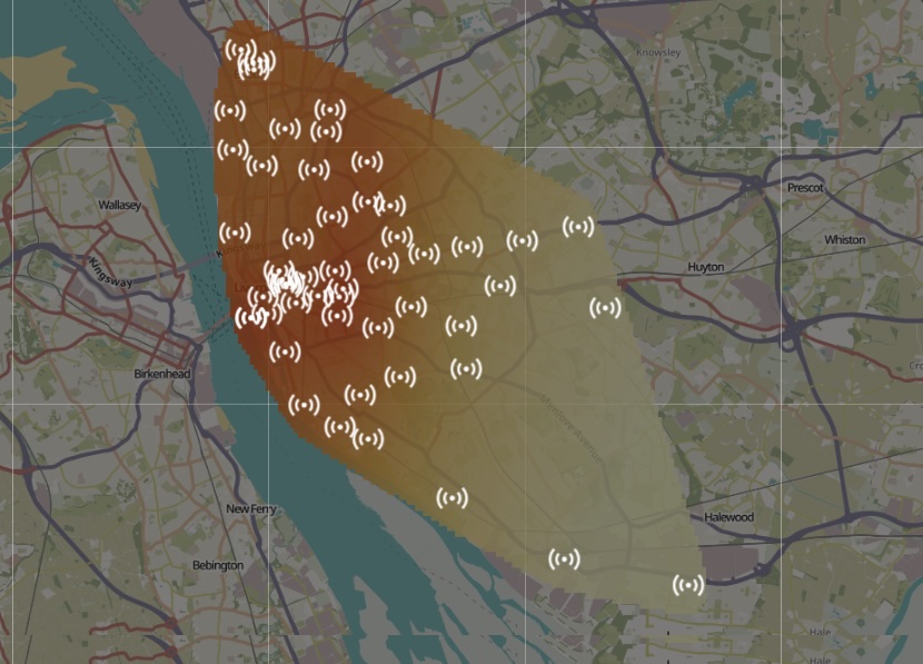
The network changed. The idea got bigger.
For several years, Liverpool's research depended on a commercially supplied city monitoring network. It proved the value of dense data — and helped generate the evidence that made the programme worth protecting.
But a commercial network also meant that the instruments, access model and long-term continuity were not fully under the University's control. By 2025, data access had become harder to sustain on the same basis and the historic feed stopped updating.
There was an obvious response: accept a smaller network and narrower research programme.
Instead, the setback created a different idea. What if Liverpool could own the capability — from the monitor, to communications, to calibration, to data infrastructure, to the way evidence reaches health partners, councils and communities?
That question is the bridge between the research you can see here and the story we are saving for 10 December.
Historic network dataset ↗Air quality is not one discipline.
Dense spatial monitoring
How can lower-cost instruments add neighbourhood-scale information without pretending to replace reference-grade monitoring?
Children + vulnerable groups
How do pollution, deprivation, housing and other social determinants combine to shape respiratory risk?
Meteorology + movement
How do wind, boundary-layer conditions, traffic and changing behaviour alter what a sensor network appears to show?
Ports + transport + infrastructure
How do major urban systems create, move and concentrate pollution — and where should interventions be tested?
Indoor + outdoor air
What happens between an ambient concentration outside and the air a child, patient or household actually breathes?
Schools + policy + communities
How does evidence become something a teacher, clinician, council, community or policymaker can genuinely use?
The evidence behind the story.
These are the outputs most directly connected to the Liverpool air quality journey. The point is not the publication count; it is how each paper changed the next question.
Effects of meteorology and human mobility on UK's air quality during COVID-19
Impact of SARS-CoV-2 variants on mobility and air pollution in the United Kingdom
Real time mapping of particulate matter concentrations and paediatric asthma emergency department visits
Application of Proper Orthogonal Decomposition to elucidate spatial and temporal correlations in air pollution across Liverpool
Spatial and temporal dynamics of air pollution and socioeconomic deprivation in Liverpool, UK
Breathing inequality: unmasking Liverpool's air pollution burden on deprived youth
Air pollution and deprivation: a double burden on Liverpool's children
Fuel Poverty in Liverpool: The Deprivation-Pollution-Housing Loop
From more data to better evidence.
The next stage is not simply to add more monitors. It is to make dense monitoring scientifically harder to misuse.
Current Liverpool work is developing meteorology-aware, reference-constrained methods that audit coverage, reference agreement, spatial uncertainty and source proxies before allowing strong interpretation. Other work is exploring particle composition and whether microscopic particle information can help distinguish chemical signatures and potential sources.
That matters because the value of a city-scale system is not that it can produce more dots on a map. It is that it can support stronger questions — and know when the evidence is not strong enough to answer them.